Welcome to
Napa County CAGenWeb
Maps
Home
Contact
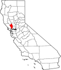
Large detail map of Napa county
BLM Land Patent Search
©
CAGenWeb All Rights Reserved. This page last up
dated:
<div class="statcounter"><a title="Web Analytics" href="https://statcounter.com/" target="_blank"><img class="statcounter" src="https://c.statcounter.com/12999768/0/db8c3eb9/1/" alt="Web Analytics" referrerPolicy="no-referrer-when-downgrade"></a></div>